Conus
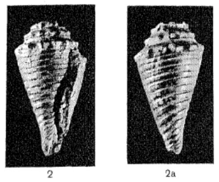
(Conospira) tiaratus (Martin, 1931)
Conus
(Conospira) tiarophorus (Tomlin, 1937)
Descrizione.
Massig schlank, mit
hohem, tiara-ahnlichem Gewincle, dessen Umgange einen etwas vor del'
Mitte gelegenen Spiralwinkel besitzen. Vor demselben ist ihre
Profillinie fast gerade, dahinter kaum merklieh ausgehohlt. Der
hintere Abschnitt zeigt ein sehmales Nahtband und vor ihm drei
gleiehe und gleich we it voneinander entfernte, scharf und zierlich
gekornelte Spiralen. Der vordere besitzt stark ausgepragte,
daehformige, vom Winkel zur vorderen Sutur reichende Knoten und zwei
scharfe, nicht unterbrochene Langsfurehen.
Die
Schlusswindung ist vorne etwas zusammengeschniirt und ganz mit
bandartigen Langsleisten bedeckt, welche etwas vor der Mitte we it
voneinander entfernt stehen. Dazu gesellen sich Anwachslinien, welche
zwisehen den Leisten zu feinen Querfaden entwickelt sind.
Nur
das dargestellte, 16 mm lange Bruchstiick ist vorhanden, welches aus
den Orthophragminenschichten des Kali Songo stammt.
Moderately slender,
with a high, tiara-like angle, the whorls of which have a spiral
angle slightly in front of the middle. In front of it its profile
line is almost straight, behind it it is hardly perceptibly concave.
The posterior section shows a semi-suture band and in front of it
three equal and equally spaced, sharply and delicately cornulated
spirals. The anterior has well-defined dah-shaped nodules extending
from the angle to the anterior suture and two sharp, uninterrupted
longitudinal sulci.
The final whorl is
somewhat laced together in front and is entirely covered with
ribbon-like longitudinal ridges, which are spaced apart slightly in
front of the middle. There are also growth lines, which have
developed into fine transverse threads between the ridges.
Only the fragment
shown, 16 mm long, is available, which comes from the orthophragmine
layers of the Kali Songo.
Epoca:
Upper Eocene
Località:
Indonesia

|
Fig. 1.
Modern geological and oceanic setting of the Nanggulan region,
central Java.
Right:
simplified geological map showing the main geological provinces
and stratigraphic units (Smyth et
al. 2008).
Oceanography after Auer et
al. (2019).
Pink shaded ocean areas represent the Indo-Pacific Warm Pool,
here delineated by the outer boundary of the 29°C isotherm.
Ocean currents, represented by arrows, show the complex surface
exchange from the Pacific Ocean through the constricted
Indonesian archipelago (Indonesian Throughflow). Green–blue
arrows indicate monsoonal freshwater discharge into the South
China Sea from major SE Asian rivers (i.e. Mekong, Pearl and Red
rivers). Shown for reference are Dieng Plateau Caldera complex,
the active stratovolcano Mount Merapi and the regional capital
cities of Semarang and Yogyakarta (2).
|
|
- Conus tiaratus
-
Tav. II - fig. 2
-
mm. 16
-
Nanggoelan
|